Land Use
History of Land Use:
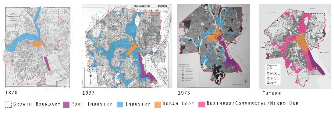
Land use in Providence has, for most of its history, been focused around manufacturing. Manufacturing plants and factories were located near ports, with high density housing surrounding those areas, followed by an external ring of single family style homes for the wealthy.
Manufacturing began initially near the port on the Providence River, so that ships in the triangle trade would have access to manufactured goods, once Providence developed past a shing-based
economy. Later, in the late 1820’s, a second, inner harbor was built. This harbor, and subsequent canal, created a whole new stretch of industrialized land. Later, manufacturing grew around rail-lines,with low-income housing continuing to follow the factories in a ring-like fashion.
Manufacturing continued to lead land use and growth in Providence until it began to collapse. First the textile industry declined in the 1920s, followed by the machine tool industry in the 1950s, and then the jewelry industry in the late 1970s. This lead to large scale urban renewal projects, focused in the 1960s, which sought to demolish the unused factories and warehouses.
Because of its current lack of industry, Providence has now attempted to rebrand itself as a creative city that focuses on education and healthcare. The city’s future land use plan has no industrial zoning. Instead, most of these previously industrial areas are
now labeled as areas for business, commerce, or mixed-use.
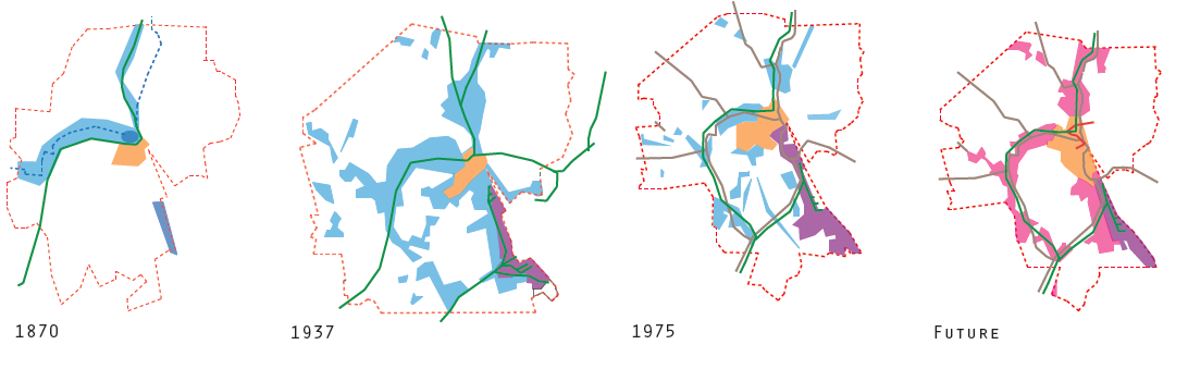
Transportation and land use in Providence, historically, have both served as a means to an end: to promote the growth of industry. The construction of ports, followed by canals, railroads, and finally highways, have all served the purpose of transporting manufactured goods to markets to be sold. It was not until the early 1980s that transportation began to be framed in the context of
effecting the quality of life of the city.
Land use in Providence followed a concentric ring hierarchy, beginning with factories and manufacturing hubs in the center, usually located near the ports. As transportation systems evolved with technology, new transportation routes were built to access these ports, and the factories near them. Low-income housing continued to grow in the areas surrounding the factories, and medium and high-income housing was located on the fringes of industrialized Providence. In the late 1960s, once industry began to collapse, the railroads shifted their focus to transporting people. This lead to an increase in housing density along commuter rail lines, to a small extent.
Commercial land uses appeared mostly along highway corridors until the 1980s, when the downtown area was revitalized with the removal of the I-195 corridor that blocked the downtown area from the rest of the city, and from the riverfront. Now the downtown area is the focus of commercial growth as well as entertainment. Where the I-195 highway previously stood, new parcels have been opened up for development. To spur development in this area, Providence has created The LINK. This body is solely responsible for the I-195 redevelopment district, conducting proposal review and approval, and zoning relief requests and subdivisions and mergers. Because the entire development process is accomplished by one body, the timeline for projects in this area is much quicker than in other parts of the city. The city is now going through the process of implementing a street car in the city. The street car will link major commercial and downtown entertainment districts in the city with the education districts and hospital districts. With the correct incentives, it is Providence’s hope that the street car will continue to push “creative class” development along the street car line, creating a stronger economic base for the city and increasing tourism.
Historical Maps
Population Density
Recent Population Density Patterns
With population in Providence peaking in the 1960s, density in the city was the highest while jobs kept workers in the city core near factories and warehouses. As these institutions collapsed, the density in Providence declined. Only in more recent years has density begun to again increase in the urban core.
With population in Providence peaking in the 1960s, density in the city was the highest while jobs kept workers in the city core near factories and warehouses. As these institutions collapsed, the density in Providence declined. Only in more recent years has density begun to again increase in the urban core.
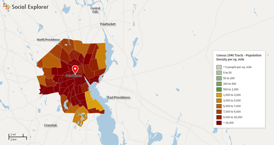
1940
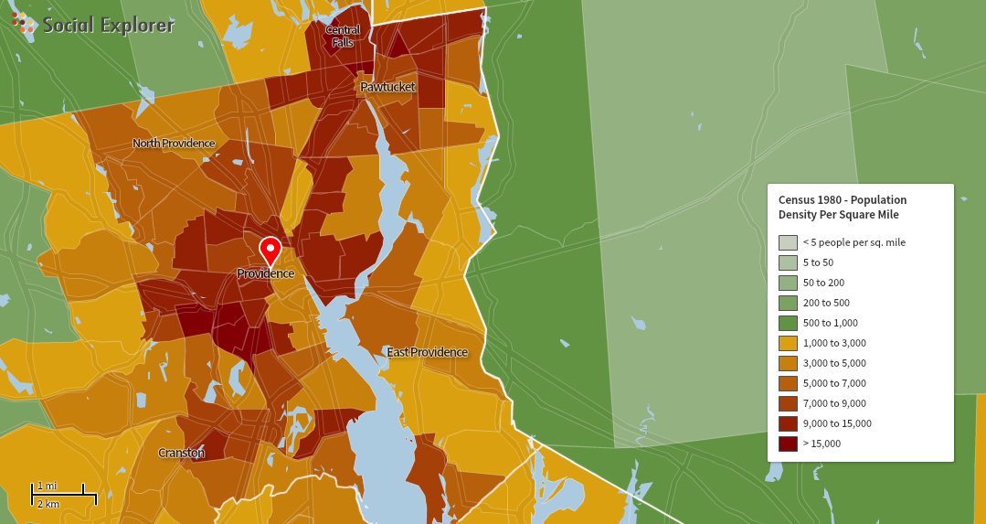
1980
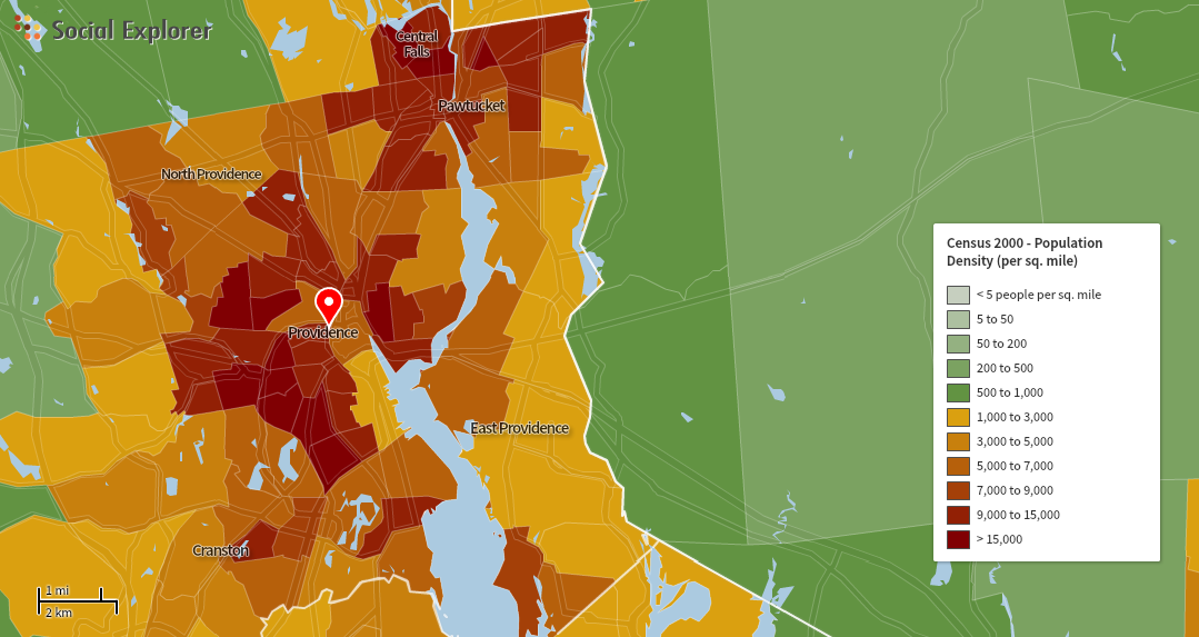
2000
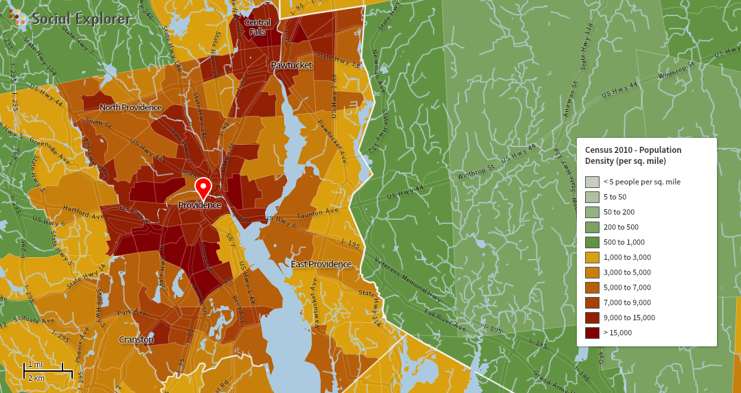
2010
