Centrality

Prior to the Civil War, Providence was, by in large, ethnically and socio-economically mixed, as well as being mixed in land usage. This was due to building patterns of the time, being mostly mixed-use and entirely walkable (Kaplan, Wheeler, and Holloway 2009). Shops and services were located next to housing, which were located near factories and warehouses near the port and railroads. Continuing into the 1800s, low-wage workers, typically being black and Irish-Catholic lived in dense neighborhoods in the city of Providence, close to employment centers. This pattern continued to thrive until the loss of industry occurred in Providence in the early 1900s. With the wealth of central Providence steeply declining, most businesses, including retail and food shops, fled the area; Providence faced a major economic redistribution.
Decentralization
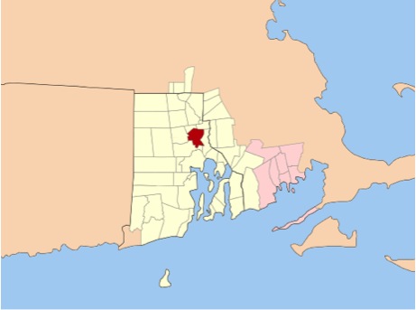
Providence Metropolitan Statistical Area
|

Pink Areas denote land annexed from Providence
|
The city of Providence has seen decentralization through most of its history. In the 1700’s, this decentralization was caused by annexation. In 1731 the towns of Scituate, Glocester, and Smithfield were incorporated, and thus the area was lost to Providence. These areas were considered the "outlands" of Providence, and were mainly farming villages. Later, Cranston, Johnston, and North Providence were also extracted from Providence. These towns were located even closer to the core of Providence. After these three inner towns were incorporated, Providence was reduced to approximately six square miles in size. Parts of these areas were later regained by the City of Providence, but the areas remained residential in nature. The six square miles of the inner city focused land use on industry and commerce. Thus, the six square mile core was centralized and catered towards the factory workers, while the outer neighborhoods in Providence were decentralized, and catered towards a wealthier class of people who favored space over the convenience of services.
In the 1940’s, suburbanization increased rapidly in the areas surrounding Providence; some of the more established immigrant populations who had gained wealth, such as the Irish-Americans, began to leave the center city for the suburbs. Today, this pattern is visible through census statistics; Providence is a city of approximately 178,432 persons in an area that is 18.40 square miles. In contrast, the metropolitan area for the city stretches to a population size of approximately 1.5 million persons.
Scituate, Glocester, Smithfield, Cranston, Johnston, and North Providence Today:
Scituate – independent town and municipality
Glocester – independent town and municipality
Smithfield - independent town and municipality
Johnston – part of the City of Providence
North Providence – independent town and municipality
Cranston – Incorporated City
